

Multimedia GIS as a Design Tool with a Case Study of New Estates in West-Brabant
Alexandra Tisma
Faculty of Architecture, Delft University of Technology Berlageweg 1 2628 CR Delft, The Netherlands e-mail: a.tisma@bk.tudelft.nl
Summary
This project intends to teach students the basics of GIS implementation in land evaluation appropriate for physical planning purposes. As it is a multimedia document it will also have to demonstrate new ways of a non-linear presentation of designs. The project "Multimedia GIS as a design tool with a case study of new estates in West-Brabant" will be used as an interactive program to be applied in education in the block "Region" of the Department of Urban planning of the Faculty of Architecture. Interaction between the students and the system will enable an evaluation of designs, produce an immediate graphic visualisation of their evaluations and enable comparison with the evaluations of fellow students. Data bases for this project will be taken over from a post-graduate project in which GIS software MAP II has been used to select locations for the "new estates" in West-Brabant.
Introduction
At the Faculty of Architecture there is no GIS training course. Some years ago an attempt was made, but it didn't succeed. The intention was to teach students the basic theoretical issues because a training course with ARC-INFO couldn't be provided due to luck of equipment. After the educational system at the Faculty of Architecture has been restructured GIS was abandoned for the same reason. Last year a new training programme is made intending to give students concise information about the possibilities of implementing GIS in regional planning. The programme comprises the multimedia project "Cyberland" and a short training with MAP II. The use of multimedia in education is recent but dynamically expanding technique. It allows students to present in an new environment, it is suitable for teachers and researchers alike and in a years to come it will change the way we think and solve the problems*1. MAP II is a raster based user friendly Macintosh application, and can be learnt in a short time.
Block "Region"
This block takes 6 weeks in the first year, and it is compulsory for all students (approximately 500). It deals with spatial structures of buildings and the built-up environment on a high level scale - region. The main themes of the block are: dynamics of spatial changes; insight into the process of spatial planning; insight into scale, size, form and typology of the Dutch landscape; traffic and infrastructure as a base for mobility; insight into characteristics and typology of building sites. These themes are worked out in 5 cases: image and reality spatial models environment or economy site related problems design. The content of the block implies to a great extent working with different kinds of cartographic material (topographic maps, plans, etc.) and aerial photographs. The implementation of GIS in this context will be to facilitate the main task of the block, and to learn students how to manipulate with digital maps.
Multimedia introduction to GIS
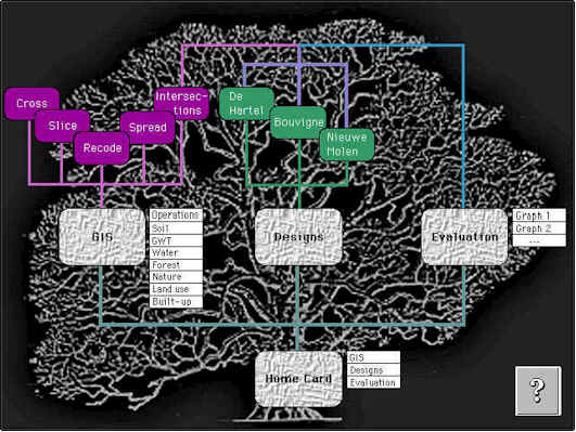
The multimedia project "Cyberland" has been derived from the post-graduate project "A GIS based planning for the re-use of agricultural land in The Netherlands with a case study of West-Brabant."*2. The essence of this study is a proposal of using some parts of surplus agricultural land in West-Brabant for the development of nature together with low density housing areas. This category of housing is given the name "new estates". In order to find the best locations for both nature development and housing, the West-Brabant area has been analysed in accordance to certain criteria using the GIS program MAP II for Macintosh. The analyses showed approximately 6000 ha of suitable locations, three of which have been chosen as examples for designs. The "Cyberland" consists of three main parts: information about main functions of GIS, information about example designs and interactive evaluation graph (figure 1):
Figure 1. Structural schema of the "Cyberland"
1. The GIS-part explains the criteria and GIS-operations used for selecting locations. The criteria are specified in texts, whereas the operations "recode", "sperad", "slice" and "cross" are explained by means of maps, sound and text. The aim of this part is to give students an idea of how MAP II can be applied in land-use evaluation.
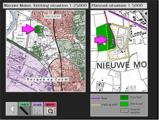
2. The second part of the project gives visual and written information about example designs for "new estates" at three locations on the city fringes of Breda and Bergen op Zoom (figure 2):
Figure 2. Location for "new estate" Nieuwe Molen
This part includes scanned maps, 2D-drawings, photos, photo montages and morphs. It aims at showing the possibilities of multimedia in an interactive presentation of designs.
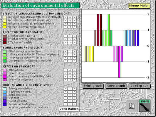
3. In the third part designs can be evaluated in accordance to their environmental effects both on housing and natural environment. Every user can create a simple evaluation table and a graph, save it and print it (figure 3). Another user can load graphs made by others and compare them with his own. This can lead to valuable discussions about the main themes of the block "Region".
Figure 3. Evaluation of environmental effects
Introduction to MAP II
The next step in the training is practical and deals with choosing locations for new housing areas in West Brabant. This is usually done in the last three weeks of the block by using topographic map of the area on a scale of 1:25000. In the period February-March of 1995 an group of 15 students will try out MAP II on the same assignment. The input maps of land use, soil and ground water levels will be prepared in advance, and the assignment formulated so that it can be carried out with the four operations: recode, spread, slice and cross.
Organisation of the training
The training will take 8 hours, explaining the general basics of GIS and individual browsing through "Cyberland" in the first and second hour respectively. Remaining six hours are to be spent on the formulation of GIS criteria for the selection of locations and working it out with MAP II. To help students with their work, a short manual of MAP II will be handed out. If this experiment succeeds attempts will be made to incorporate GIS-training in the regular program of the first year.
References
1. Ambron, S. (1990): New visions of reality: Multimedia and education. Interactive multimedia. Microsoft Press.
2. Tisma, A. (1994): A GIS based planning for the re-use of agricultural land in The Netherlands with a case study of West-Brabant. Conference proceedings of EGIS/MARI 1994, Paris, vol. 2, 2002-2003.