


'REGIO' Software - A Tool for Design and Evaluation of Regional Plans
ir. A. Tisma, research scientist
Faculty of Architecture TU Delft. Berlageweg 1, 2628 CR Delft, The Netherlands, tel ..31-15-2781689, e-mail: a.tisma@bk.tudelft.nl
Prof. ir. D.H. Frieling
Department of Urban Design, Faculty of Architecture TU Delft, Berlageweg 1, 2628 CR Delft, The Netherlands, tel. ..31-15-2784143
Abstract: 'REGIO' software is a new application specially developed for the first year students of the Faculty of Architecture, for the course 'Region'. The application integrates some functions of Geographical Informational Systems with multimedia and drawing facilities. The software aims to improve educational effectiveness of students in learning of regional planning by saving the time which is usually spent on long lasting routine operations and reusing it for substantial understanding of effects of actions. The first experimental implementation of the software in experimental group of students was successful.
1 INTRODUCTION
Physical planning is a complex dynamic process which involves taking decisions regarding different spatial components and socio-economic agents. That is the subject the students of the Architectural Faculty have to deal with in the course 'Region' during the first year of their studies. During 8 weeks of the course, students are faced with the field of physical planning which is for them quite abstract as their background knowledge about it is relatively weak. The design task is to develop the plan for the 70.000 new dwellings and 70.000 new work places within the Randstad, a highly urbanised area in the west of The Netherlands fringed by the cities of Amsterdam, Rotterdam, The Hague and Utrecht.
Within this context the learning goal of 'REGIO' software is to provide students with a tool which will allow them to create plan, to test if the plan fulfils the programme (technical evaluation) and to consider the alternative plans in a social context (social evaluation). For the purposes of technical evaluation 'REGIO' software simulates a part of functionality of geographic informational system (GIS) which are integrated with drawing and multimedia environment.
For the social evaluation software 'REMBRANDT', based on the multi-criteria decision analyses will be used. This paper will concentrate on development and implementation of the 'REGIO' software.
1.1 GIS and Multimedia
It is generally acknowledged that human beings learn best through first hand experience, by trial and error [Senge 1990]. The problems of experiencing the real world situations in spatial or environmental systems are related with the fact that, since they are usually complex systems, the consequence (feedback) from our actions are neither immediate nor unambiguous, being often far removed in time and space [Senge 1990]. On the other hand, the consequences of our interventions can sometimes be rather damaging if they are performed in a real environmental system. Therefore the use of simulation can help to understand the consequences of actions, and in our case computer simulation is considered as the best technique to help students to understand the effects of the changes they are "making" in urban space.
The use of multimedia in education is recent but dynamically expanding technique. Multimedia can be defined as a variety of analogue and digital forms of data that come together via common channels of communication [Laurin and Thompson 1991]. By most definitions multimedia generally refers to applications which handle static media such as text and graphic in raster and vector form, as well as dynamic media such as time series data, animation and video, either locally or through networks. As such, the term multimedia really refers to the technology of data integration and presentation and does not imply any specific method of information organisation.
Although the attempts to integrate multimedia and GIS have been explored by many researchers [Raper 1994, Camara 1994, Bijtelaar 1994, etc.] until now, no completely satisfying software has been developed. Therefore, in order to create 'REGIO' software, we decided to simulate GIS functionality and operations in the multimedia environment.
1.2 The Nature of Interactive Learning
Learning Interaction and interactivity are fundamental to all dynamic systems, particularly those involving people [Barker 1993]. Interaction between the systems depends upon the "flow" which involves the movement of material, energy and information from one system to another. Interactivity can occur between both human-human and human-computer systems.
In the case of human-human interaction, the processes involved are usually of a cognitive nature and the message passing most often takes the form of speech acts, gestures and tactile dialogue. The states involved are knowledge states. As a result of a dialogue process, the communicating partners therefore learn more about each other or about the topic of discourse.
In the case of human-computer interaction, the processes involved are cognitive and computational, respectively. The message passing in this case usually involves the computer screen, mouse or keyboard which are used with a suitably designed graphical user interface. This technology allows the use of different kinds of media, such as static and moving images, sound and text.
If the computational processes involved in human-computer interaction (such as simulations, surrogations and knowledge/information presentation) are designed correctly, they can be used to initiate and stimulate cognition, reflection, thinking, creativity and learning.
Technically, if suitable telecommunications facilities are available, this type of learning can be widely represented and independent of geographic location. The active research and development currently is directed into "intelligent" tutoring systems and design of computer-based cognitive tools to support automatic tuition.
2 METHODOLOGY OF SOFTWARE DEVELOPMENT
The outline plan of software development is defined involving the following key phases:
1 agreement on lesson content
2 lesson design
3 programming of the software
4 system integration and testing
2.1 Lesson Content
As the intention is to include the 'REGIO' software as a 'self learning' lesson element within an existing traditional course on regional planning, it was necessary to choose a subject area which has previously been covered during the course and which would build upon users' existing knowledge of the subject.
The Course 'Region' takes 8 weeks in the first year of curriculum of the Faculty of Architecture. It is compulsory for all the students (approximately 400). It deals with the spatial structures of buildings and the built-up environment on a high level of spatial scale - region. The main themes of the block are: dynamics of spatial changes; insight into the process of spatial planning; insight into scale, size, form and typology of the Dutch landscape; traffic and infrastructure as a base for mobility; insight into characteristics and typology of building sites. These themes are worked out in 5 cases:
- image and reality
- spatial models
- environment or economy
- site related problems
- design of the Randstad area.
The content of the block implies to a great extent working with different kinds of cartographic material (topographic, historic and thematic maps, plans, etc.) and aerial photographs.
In the fourth week of the block students are confronted with the task of selecting of the new locations for urban extensions within the Randstad area. First they develop a model of the plan and they test it according to the stated programme which is 70.000 new dwellings and 70.000 new working places accompanied with adequate infrastructure, facilities and recreational zones. The testing occurs by using the raster of 1x1 km which is laid over the topographic map of the area (25x25cm) and than they check weather each of the cells in the plan corresponds to the programme. After the test was done, the model of the plan can be modified by re-grouping the cells or adding missing spatial components where the test had shown that they are lacking.
The software 'REGIO' is used to replace this time consuming process of designing by hand (drawing - testing- re-designing) with automated computer procedure that lasts only few minutes. The structure of the software is shown on the figure 1.
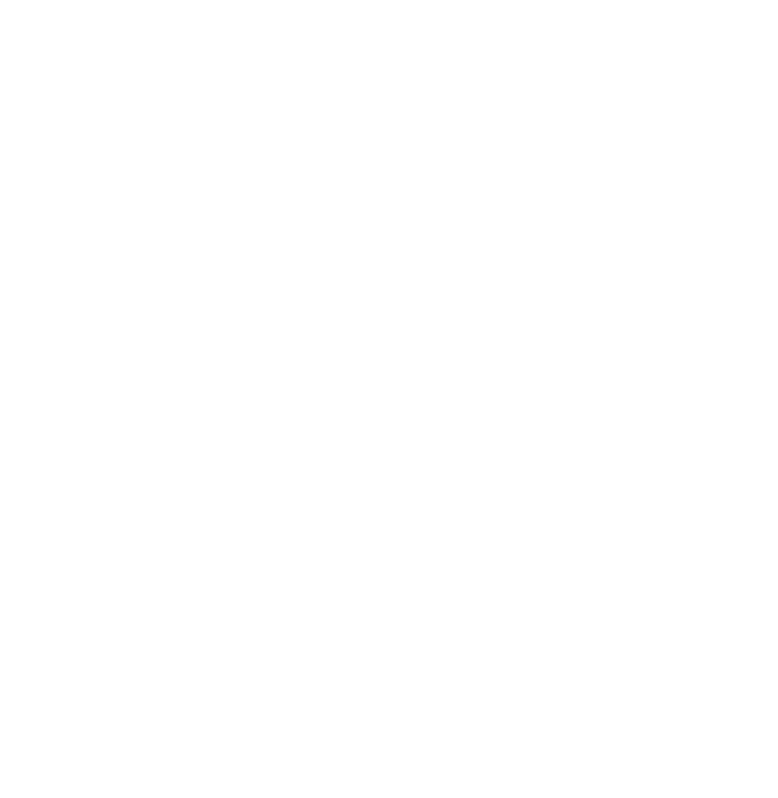
Figure 1. The structure of 'REGIO' software and the position within the content of the lesson
2.2 Lesson Design
The time duration of the training was eight hours. The lesson involved four phases:
1. An introduction meant to provide the basic knowledge about the use of the 'REGIO' application
2. Individual work on development of the plan by using 'REGIO' software
3. Technical evaluation of the plan by using 'REGIO' software. In this stage students checked if their plans fulfil the programme.
4. Re-design/re-evaluation. If the evaluation showed that the plan does not correspond to the programme to a large extent, students re-designed and evaluated again until the satisfactory result was found. This could be repeated as many times as necessary.
5. Social evaluation occurred through group work by simulation of the decision making process which involved different parties such as users, governmental instances, investors and builders. The 'REMBRANDT' software [Lootsma 1992] was used for this purpose.
2.3 Programming of the Software
The 'REGIO' software is programmed in Delphi, object oriented programming language suitable for Windows system. It consists of informational, drawing and testing environments. Informational part contains visual information about the Randstad area with examples of planning categories in lower scale. Drawing environment has basic tools necessary to design the plan - pen, eraser, zoom and pallet of colours. Testing environment provides all the calculations based on the difference between the existing and planed situation [see Figure 2].
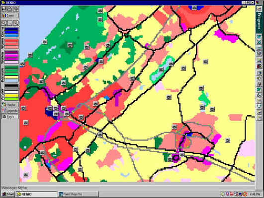
Figure 2. 'REGIO' interface. Screen with drawing tools and position for photo images
2.4 System Integration and Testing
The performance of the application was tested on several computers. The function of links, speed of performance and occurrence of bugs was considered in testing. After the last tuning was done the application was implemented in experimental group.
3 SYSTEM EVALUATION IN THE LEARNING ENVIRONMENT
In April this year the 'REGIO' software was for the first time implemented in education, within the experimental group of eight students. During the work with them information about the use of software and its value for learning of the content of the exercise was obtained in two ways:
a. by recording the direct observations of the mentor of the group, assistant and myself,
b. by interviewing the participating students.
The analyses of this information show that:
the amount of time needed to do complete exercise (designing and testing) was approximately 4 times shorter by use of computer that without it ,
the precision of work was 10 times higher by computer than by hand (squares of 1ha in place of 1km2)
adjustment of designs occurred always by computer and almost never by hand
creation of alternatives was often done by computer and never by hand
all students found that working with 'REGIO' software was easy and pleasant
students found that 'REGIO' software is absolutely better for the exercise "Case 3: Global plan testing", but not fine enough to do their final design
the reasons for that are: too large pixel to design smaller line elements like water, roads, bicycle paths; missing underlayer of topographic map which makes spatial and landscape structure invisible; missing of thematic layers, etceteras.
4 CONCLUSIONS
The evaluation identified the educational effectiveness of the software based on the training that is carried out in a group of 8 students. The evaluation activities collected and summarised information about the software and its value for learning of regional planning.
The objectives of the evaluation were to measure skills acquisition in the development of spatial models by comparing the skill acquisition of the students by receiving usual class teaching with conventional materials to the skill acquisition of the same students by using 'REGIO' software. Evaluation was done on the basis of the analyses of the questionnaires that students filled at the end of the day.
The results of the analyses showed that the skills acquisition of the students was considerably higher in the second case, as they could faster and more realistic get the insight in the urban expansion of the study area, they could make several alternative plans, seeing immediately when the problems appeared, they could adjust the plans and easily test them again.
REFERENCES
[Bijtelaar 1994] Bijtelaar, B. (1994): GIS and multimedia: how to integrate? Proceedings of the workshop on GIS and Multimedia, EGIS/MARI conference, Paris.
[Camara 1994] Camara, A. (1994): Applications of multimedia GIS. Proceedings of the workshop on GIS and Multimedia, EGIS/MARI conference, Paris.
[Barker 1994] Barker, F. (1994): Designing interactive learning. Design and Production of Multimedia and Simulation-based Learning Material. Kluwer Academic Publishers, Dordrecht.
[Laurin and Tomson 1991] Laurin, R. and Tomson, D. (1991): Fundamentals of spatial information systems. Academic Press, London.
[Lootsma 1992] Lootsma, F.A. (1992): The REMBRANDT system for multi-criteria decision analyses via pairwise comparison or direct rating. Report 02-05, Faculty of Technical Mathematics and Informatics, TU Delft.
[Rapper 1994] Rapper, J. (1994): Progress in spatial multimedia. Proceedings of the workshop on GIS and Multimedia, EGIS/MARI conference, Paris.
[Senge 1990] Senge, P.M., 1990: The fifth discipline. The art and practice of the learning organisation. Doubleday Currency, New York.
